On the trail of a noble Spoon
Having discovered my bearings with the enabling of HTC Trinity's GPS receiver, I decided to explore a little more what the device could do.
My first significant experiment was to use with the aid of VisualGPSCE log a train journey from Oxford to Worcester and beyond. Similarly I logged another journey in Worcestershire - a visit to Chaddesley Wood to see if the bluebells were starting to appear (there were some signs, but not yet a profusion of colour). VisualGPSCE records data in a standard GPS log file. From my PDA I uploaded the output to GPS Visualizer, which is a sophisticated online service that can overlay your data on Google Maps or even embed in 3D in Google Earth. I initially tried to generate a Google hybrid map but Pocket IE couldn't render it, so I next chose to simple output in the form of a JPEG:

The track is coloured (ranging from red through the colours of the rainbow to magenta) according to altitude or speed - looking at the track, I think it has indicated speed. I also logged a track in the woods and took a few photos during this time. Provided the camera and GPS clock are reasonably in sync, you can faithfully combine the path data with the images taken from the camera, i.e. geotagging the images. It's again a new area for me so I don't yet know many options, though the Robogeo site lists a number of techniques (as well as offers its software) to solve the problem.
However, an easier solution is for the camera to record GPS details with the photo and as it happens the HTC does indeed have this ability: I entered "HTC P3600 EXIF" into Google and landed on the info I needed to know on Erwin van Hunen's Mobile Viking blog. Indeed, with the ROM upgrade, there has been some enhancement of the camera software, Camera for Pocket PC, now is at Version 4.02. If you access the camera settings and paddle along to settings for Capture Mode and navigating down the menu, at the bottom is the option for 'GPS Photo'. Once you've selected that, then when you come to take a photo the centre of the screen greys out and a message reads 'Initializing GPS...' As that is all it says, on switching on I tend to establish a connection and lock with VisualGPSCE and once I've got a lock I then switch over to the camera, which initializes very quickly.
From then on it's as easy as taking normal photos - I didn't notice any difference in the speed to take snaps. Camera data is stored in EXIF format and GPS details get added - the GPS version ID plus longitude, latitude and time. Ah, on looking a bit more closely, I see that the GPS system has atomic clock time and my PDA is about 1 minute fast! (I now have fixed that manually, but I wonder if there is a nice simple sync utility for the mobile?)
You may be wondering at this stage what the title is about! Well, it's meant to be a very easy little mystery tour - where did I go? I was on the way to visit a large wooden family, somewhere in the city of Oxford. I took a stroll along the canal, keeping a GPS log. I started somewhere in Northern part and took the following photo (click for essential information!)
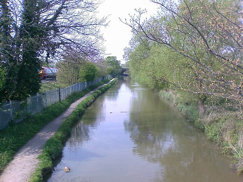
About 2 miles down the canal I crossed a footbridge and then took a zigzag route, walking for a further 10 minutes or so towards the centre. I passed a legal publishers and a few hundred metres on as I approached my destination it was getting busier with tourists. I then took a left turn and entered a large building, descended some steps and met the family:

But there was one Spoon I was particularly interested to meet and here he was:

But who was he and where was I? You can click on the link to find out and confirm!
[As part of Oxfordshire's 1000 Years celebration, a collective work of art has been created through the transformation of 1000 wooden spoons. It's called the Spoon Race .]
I hope you enjoyed today's GPS journey :-)
posted by Paul Trafford at 10:31 am
![]()

0 Comments:
Post a Comment
<< Home